Title and statement of responsibility area
Title proper
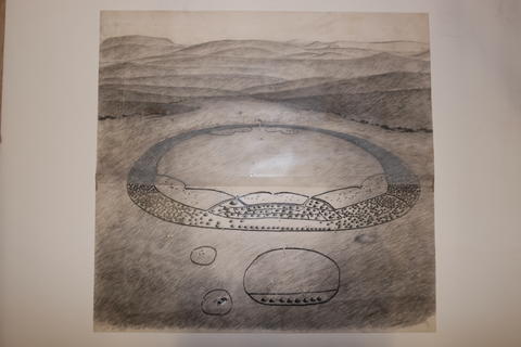
Drawing depicting uMgungundlovu post-1835
General material designation
- Textual record
Parallel title
Other title information
Title statements of responsibility
Title notes
- Source of title proper: Chloe Rushovich for FHYA using Frans and Hester Roodt's materials
Level of description
Item
Repository
Reference code
Edition area
Edition statement
Edition statement of responsibility
Class of material specific details area
Statement of scale (cartographic)
Statement of projection (cartographic)
Statement of coordinates (cartographic)
Statement of scale (architectural)
Issuing jurisdiction and denomination (philatelic)
Dates of creation area
Date(s)
-
2020 - (Online curation)
- Online curation
- Five Hundred Year Archive (FHYA)
- Note
- Digital image by Hester and Frans Roodt
Physical description area
Physical description
Publisher's series area
Title proper of publisher's series
Parallel titles of publisher's series
Other title information of publisher's series
Statement of responsibility relating to publisher's series
Numbering within publisher's series
Note on publisher's series
Archival description area
Custodial history
Scope and content
Notes area
Physical condition
Immediate source of acquisition
Arrangement
Language of material
Script of material
Location of originals
Availability of other formats
Restrictions on access
Terms governing use, reproduction, and publication
Creative Commons License: CC BY-NC-ND
https://creativecommons.org/licenses/by-nc-nd/3.0/
Unless otherwise stated the copyright of all material on the FHYA resides with the contributing institution/custodian.
Finding aids
Associated materials
Accruals
General note
Attributions and conjectures
[Source - Frans Roodt for FHYA, 2020: Frans Roodt directed Hester Roodt (nee Lewis) to do this drawing in 1992. The image was an attempt to compose a perspective drawing of uMgungundlovu based on the archaeological site plan of 1992. The landscape is based on an aerial photo of about a 45-degree angle, photographed from a light aircraft flying over the site from south to north. The hills in the background are realistic.
After finding and excavating an extraordinary large hut on the western side (right hand side) of the isigodlo in 1992, which fitted the descriptions of King Dingane’s hut by three contemporary visitors to uMgungundlovu (Retief, Owen and Champion), the standard narrative about the layout of uMgungundlovu was assessed more critically. This hut did not fit the well-known drawing and description of the King’s hut by Gardiner (1835), nor the placement of it on the eastern (left hand side) of the isigodlo in all the reconstructions such as James Stuart’s and others. A leading clue was Gardiner’s sketch depicting a “distant race course” effect. Read together with the account that the town was being rebuilt, but still incomplete (as depicted in his sketch). In a footnote he mentions that huts were moved to the open space shown on his sketch (Gardiner, AF. 1966. Narrative of a Journey to the Zulu Country in South Africa. Cape Town. C. Struik).
After discovering the hut mentioned above, Frans did a reconstruction of the isigodlo area, which is depicted in this landscape drawing prepared by Hester to place the King’s hut in it correct position as opposed to previous reconstructions. This prompted Frans to publish the article: Roodt, F. 1992. Koning Dingaan se woonhut by Mgungundlovu. South African Journal for Ethnology 15 (4). Frans argued and recognised the fact that uMgungundlovu had been enlarged in 1835, that a new hut has been built for the King (which was the one described by Retief, Owen and Champion), and used the archaeological finds to reconstruct the layout of the black isigodlo, the King’s hut and upper cattle kraal. This meant that the earlier depictions of uMgungundlovu, such as James Stuart’s, on which all others were constructed (Lawton, Chadwick, etc.), reflected uMgungundlovu prior to 1835. Major differences were the enlarged ikhanda, the King’s rebuilt hut, and there was now only a single homestead behind the settlement, namely the uBheje, versus three as previously reported.]
Alternative identifier(s)
Standard number area
Standard number
Access points
Subject access points
Place access points
Name access points
- Five Hundred Year Archive (FHYA) (Online curation)
- Frans Roodt (Custody)
- Hester Roodt (Custody)


Material contributed by members of the public
Building an archive is a collective endeavour. Please help us grow the FHYA knowledge base.
If you want to add information to this page you can insert a hyperlink, add files and/or text to the box below.
In the case of material relevant to the FHYA as a whole please upload information HERE.
The FHYA does not vet this material but reserves the right to remove anything deemed to be racist, homophobic, sexist or otherwise offensive. Everything on the FHYA is licensed under a Creative Commons CC BY-NC-ND licence.
To make a contribution you must be a registered user. To register an account, click here. Note that after registration you will not be automatically redirected to this page.
If you have already registered but are not logged in, log in here.