Área de título y declaración de responsabilidad
Título apropiado
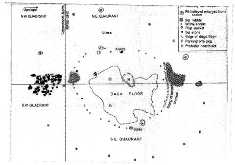
Quadrant Plan of Excavations
Tipo general de material
- Documento textual
Título paralelo
Otra información de título
Título declaración de responsabilidad
Título notas
- Fuente del título: Chloe Rushovich for FHYA using eThembeni materials
Nivel de descripción
Unidad documental simple
Institución archivística
Código de referencia
Área de edición
Declaración de edición
Declaración de responsabilidad de edición
Área de detalles específicos de la clase de material
Mención de la escala (cartográfica)
Mención de proyección (cartográfica)
Mención de coordenadas (cartográfica)
Mención de la escala (arquitectónica)
Jurisdicción de emisión y denominación (filatélico)
Área de fechas de creación
Fecha(s)
-
2016 - (Online curation)
-
1978 (Making)
Área de descripción física
Descripción física
Área de series editoriales
Título apropiado de las series del editor
Títulos paralelos de serie editorial
Otra información de título de las series editoriales
Declaración de responsabilidad relativa a las series editoriales
Numeración dentro de la serie editorial
Nota en las series editoriales
Área de descripción del archivo
Historial de custodia
Alcance y contenido
Área de notas
Condiciones físicas
Origen del ingreso
Arreglo
Idioma del material
Escritura del material
Ubicación de los originales
Disponibilidad de otros formatos
Restricciones de acceso
Condiciones de uso, reproducción, y publicación
Creative Commons License: CC BY-NC-ND
https://creativecommons.org/licenses/by-nc-nd/3.0/
Unless otherwise stated the copyright of all material on the FHYA resides with the contributing institution/custodian.
Instrumentos de descripción
Materiales asociados
Acumulaciones
Nota general
Attributions and conjectures
[Source - Chloe Rushovich for FHYA using information provided by Gavin Whitelaw, 2018: In his report, Oliver Davies writes “Professor Parkington, when he surveyed the site in 1974, put pegs in to mark what appeared to be sites of huts, and some of these have escaped the depredations of fuel-seekers. One of them was in the area now laid out, on the south of the access road.” This is the hut floor illustrated in the quarant plan of excavations. The plan is undated, but it is redrawn from the hand drawn excavation field plans, which were done during the 1978 fieldwork. Two versions of these plans were drawn, Hand Drawn Excavation Plan B and Hand Drawn Excavation Plan C, and were made either by two separate fieldworkers and/or their assistants, or by the same fieldworker and/or assistant at different times. Davies drew the publishable version from the “much more carefully done” one. To him, the other looked “very muddled”.]
Identificador/es alternativo(os)
Área de número estándar
Número estándar
Puntos de acceso
Puntos de acceso por materia
Puntos de acceso por lugar
Puntos de acceso por autoridad
- Five Hundred Year Archive (FHYA) ()
- KwaZulu-Natal Museum (KZNM) (Custodia)
- Oliver Davies (Colección)


Material contributed by members of the public
Building an archive is a collective endeavour. Please help us grow the FHYA knowledge base.
If you want to add information to this page you can insert a hyperlink, add files and/or text to the box below.
In the case of material relevant to the FHYA as a whole please upload information HERE.
The FHYA does not vet this material but reserves the right to remove anything deemed to be racist, homophobic, sexist or otherwise offensive. Everything on the FHYA is licensed under a Creative Commons CC BY-NC-ND licence.
To make a contribution you must be a registered user. To register an account, click here. Note that after registration you will not be automatically redirected to this page.
If you have already registered but are not logged in, log in here.