Zone du titre et de la mention de responsabilité
Titre propre
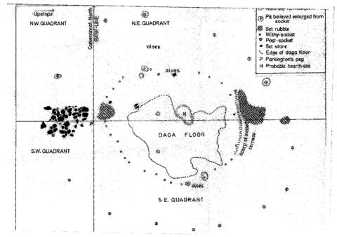
Quadrant Plan of Excavations
Dénomination générale des documents
- Document textuel
Titre parallèle
Compléments du titre
Mentions de responsabilité du titre
Notes du titre
- Source du titre propre: Chloe Rushovich for FHYA using eThembeni materials
Niveau de description
Pièce
Cote
Zone de l'édition
Mention d'édition
Mentions de responsabilité relatives à l'édition
Zone des précisions relatives à la catégorie de documents
Mention d'échelle (cartographique)
Mention de projection (cartographique)
Mention des coordonnées (cartographiques)
Mention d'échelle (architecturale)
Juridiction responsable et dénomination (philatélique)
Zone des dates de production
Date(s)
-
2016 - (Online curation)
-
1978 (Making)
Zone de description matérielle
Description matérielle
Zone de la collection
Titre propre de la collection
Titres parallèles de la collection
Compléments du titre de la collection
Mention de responsabilité relative à la collection
Numérotation à l'intérieur de la collection
Note sur la collection
Zone de la description archivistique
Historique de la conservation
Portée et contenu
Zone des notes
État de conservation
Source immédiate d'acquisition
Classement
Langue des documents
Écriture des documents
Localisation des originaux
Disponibilité d'autres formats
Restrictions d'accès
Délais d'utilisation, de reproduction et de publication
Creative Commons License: CC BY-NC-ND
https://creativecommons.org/licenses/by-nc-nd/3.0/
Unless otherwise stated the copyright of all material on the FHYA resides with the contributing institution/custodian.
Instruments de recherche
Éléments associés
Accroissements
Note générale
Attributions and conjectures
[Source - Chloe Rushovich for FHYA using information provided by Gavin Whitelaw, 2018: In his report, Oliver Davies writes “Professor Parkington, when he surveyed the site in 1974, put pegs in to mark what appeared to be sites of huts, and some of these have escaped the depredations of fuel-seekers. One of them was in the area now laid out, on the south of the access road.” This is the hut floor illustrated in the quarant plan of excavations. The plan is undated, but it is redrawn from the hand drawn excavation field plans, which were done during the 1978 fieldwork. Two versions of these plans were drawn, Hand Drawn Excavation Plan B and Hand Drawn Excavation Plan C, and were made either by two separate fieldworkers and/or their assistants, or by the same fieldworker and/or assistant at different times. Davies drew the publishable version from the “much more carefully done” one. To him, the other looked “very muddled”.]
Identifiant(s) alternatif(s)
Zone du numéro normalisé
Numéro normalisé
Mots-clés
Mots-clés - Sujets
Mots-clés - Lieux
Mots-clés - Noms
- Five Hundred Year Archive (FHYA) ()
- KwaZulu-Natal Museum (KZNM) (Conservation)
- Oliver Davies (Collection)


Material contributed by members of the public
Building an archive is a collective endeavour. Please help us grow the FHYA knowledge base.
If you want to add information to this page you can insert a hyperlink, add files and/or text to the box below.
In the case of material relevant to the FHYA as a whole please upload information HERE.
The FHYA does not vet this material but reserves the right to remove anything deemed to be racist, homophobic, sexist or otherwise offensive. Everything on the FHYA is licensed under a Creative Commons CC BY-NC-ND licence.
To make a contribution you must be a registered user. To register an account, click here. Note that after registration you will not be automatically redirected to this page.
If you have already registered but are not logged in, log in here.